Does Manila really need another reclamation?
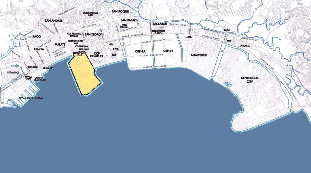
A proposed 148-hectare reclamation project— roughly half the size of the Bonifacio Global City and McKinley Hill combined—was back on the table. Stopped in 1992, the project covers the southern portion of the bay including portions fronting the Manila Yacht Club and the Philippine Navy. It was revived through an agreement between the City of Manila and Manila Goldcoast Development Corporation in April of 2012. The project aims to develop a “business center” in the northern parcel of the Manila-Cavite Coastal Road Reclamation Project.
Originally conceived and given the approval in March 1991 by the then Public Estates Authority (now the Philippine Reclamation Authority, or PRA), the project was stopped by virtue of a 1992 ordinance of the City of Manila prohibiting any reclamation in the area, as part of its efforts to preserve Manila Bay. The Office of the President also ordered the project stopped.
These decisions were spurred by massive citizen objection. But that April, the PRA reaffirmed its 1991 awarding of the project to Goldcoast. At the same time, the Manila City Council also passed Ordinance No. 8233 authorizing Mayor Alfredo Lim to apply for the reclamation with the PRA, thus effectively repealing the 1992 ordinance banning reclamation on Manila Bay.
The City subsequently entered into an agreement with Goldcoast on the condition the city be given a share in the reclaimed land. Goldcoast would fund and execute the reclamation while the city would facilitate the right of way, provide utilities and even labor. Sharing of the proceeds would be 70 percent for Goldcoast and 30 percent for the city.
It has been Mayor Lim’s dream to create a “financial center” in Manila since his first term as Mayor. He has since been trying to convince various organizations to carry out his dream, but has not been successful. One of these organizations was the Philippine Ports Authority (PPA) whom he asked to set aside a portion of the Manila South Harbor across Intramuros which the PPA aims to redevelop into a mixed-use complex. The PPA had agreed to Mayor Lim’s request, but the plan has not prospered for one reason or another.
Now, it appears that Mayor Lim has found the vehicle in the Goldcoast reclamation project to realize his dream. But does Manila need another reclamation?
Environmental Implications
Reclamation, by its very nature, is an environmentally invasive activity. It basically alters the natural ecological system of shorelines and coastal areas. It is also an expensive alternative to creating more land supply for urban development purposes. Constructing roads and buildings on reclaimed land is also expensive because of the additional reinforcement required. Buildings on reclaimed land also tend to sway more violently during earthquakes, not to mention their higher risk to tsunami.
Furthermore, in addition to the ecological and economic reasons against further reclamation in Manila Bay, reclamation is also a major cause of widespread flooding. An example of this is the Dagat-dagatan housing development in Navotas, adjacent to the Tondo Foreshore urban redevelopment project, which was developed in the late 1960s to accommodate the thousands of informal settler families displaced by the Manila North Harbor Container Port. According to various reports, the Dagat-dagatan project has caused severe flooding in the coastal communities in Navotas and Malabon which never flooded before, because it lengthened the distance that flood waters have to travel to drain out to the sea.
Open to Manila Bay on the west and to Laguna Lake in the southeast, Metro Manila constitutes a vast urbanized drainage basin that experiences frequent inundations from overflowing rivers and storm waters which the existing system of esteros and canals constructed during the Spanish and American periods can no longer handle. Despite the growing vulnerability of much of the metropolitan area, however, rapid urbanization has continued unabated with residential, industrial, and commercial land uses increasingly exposed to flood-related destruction.
Flooding has been a feature of daily life in Manila since at least the 19th century. When rains were particularly strong or tides were high, the natural drainage system was unable to cope with the sudden volume of water and the city was turned into one vast lake. The gradual expansion of the urban area into the surrounding marshes, primarily through reclamation, only increased the frequency and magnitude of such inundations. Over the years, rapid population growth, changes from open to urbanized lands, and environmental factors have combined to magnify the nature and extent of flooding in the metropolis.
Apart from the factors that predispose Metro Manila to flooding, such as topography, annual rainfall, typhoons, tidal variations, storm surges, and poor drainage capacity of soils, its vulnerability is increased considerably by human actions such as reclamation. Climatic and environmental factors, which themselves are evolving over time, partly as a result of natural processes and partly from human-induced ones, also inter-relate in complex ways with the changes brought about as a result of human activity to make Metro Manila more vulnerable to floods.
These improper land management practices directly increase the vulnerability of Metro Manila to floods as more and more lands are allowed to be developed into impermeable, or non-water-absorbing, urban sites.
Manila and the other component cities need to look beyond the confines of their respective jurisdictions and accept the fact that they are part and parcel of a single floodplain, a vast urbanized drainage basin which does not respect political boundaries.
The history of urban development and flooding in Metro Manila has been one of lost opportunities and uncertainty. Patronage politics, lack of commitment to planning and implementation, weak regulation enforcement, and inadequate urban management capacity have created conflicts of interest and rent-seeking strategies that have resulted in a mega-city that is exposed to high levels of disaster risk.
If more reclamation is carried out in Manila Bay, it is more likely that in the near future, flooding in Metro Manila will get worse before it gets better. The pressures of rapid and massive population growth and urbanization are simply outpacing the capacity of Metro Manila—whether this is taken to be the 17 local governments, or the Metropolitan Manila Development Authority (MMDA), or combined as one entity including the national government agencies based in the metropolis—to plan, manage and fund the more environmentally sensitive pattern of metropolitan development.
Under this future scenario, the most that can realistically be expected in the short term is for all the local governments comprising the metropolis to have in place proper disaster preparedness plans. But if Metro Manila is to develop as a flood-free mega-city, Manila and the other component cities need to look beyond the confines of their respective jurisdictions and accept the fact that they are part and parcel of a single floodplain, a vast urbanized drainage basin which does not respect political boundaries.
If this acceptance is achieved, then the preparation of an ecologically-based regional plan can proceed. Unless this happens, Metro Manila will likely not only remain vulnerable but even become highly susceptible to more frequent and severe disasters in the face of climate change.
Cultural Heritage Implications
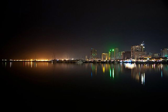
When the original proposal was submitted in 1991, one of the major objections to the project came from the private businesses and residents in the Malate-Ermita area who wanted to retain the scenic view of Manila Bay and its famous sunset. At that time, then Secretary of Tourism Rafael Alunan supported this position. From a cultural heritage conservation viewpoint, the Manila Bay sunset is considered a highly significant natural cultural asset which provides Manila its unique identity and sense of place, thus worthy of preservation.
Recently, a proposal has been submitted to the National Committee on Monuments and Sites of the National Commission for Culture and the Arts (NCCA) recommending the declaration as a National Cultural Treasure, as a National Historical Landmark and as Important Cultural Property, the portion of Roxas Boulevard from Rizal Park up to the Cultural Center of the Philippines, including the boulevard itself and the waters of Manila Bay extending therefrom as well as the view of the Bay, Cavite, Corregidor, and Bataan from the promenade and seawall.
This proposal cites that the area and its immediate vicinity are where the Rajas of Manila (Soliman and Matanda) fought the troops of Martin de Goiti and Miguel Lopez de Legazpi; where British troops landed in 1762 (near Malate Church); and where American forces landed in 1898 after the Battle of Manila Bay. It is the only public and park area in Manila where one can clearly see Cavite where the Manila Galleon docked for close to 300 years, and the Corregidor and Bataan Peninsula (with Mount Samat) where heroes of World War II fought and died.
According to Dr. Jaime C. Laya, former Chairman of the National Commission for Culture and the Arts, the area as well as the adjacent waters clearly qualify for the declaration as a National Cultural Treasure under Republic Act 10066, being a “cultural property [site] having exceptional cultural, artistic, and historical significance to the Philippines…” Dr. Laya further explains that it also qualifies for declaration as a Historical Landmark, being a “site . . . associated with events or achievements significant to Philippine history . . .” The area further qualifies for declaration as a Historical Shrine, being one of the country’s “historical sites . . . hallowed and revered for their history or association . . .”
Apart from this historical significance, the incomparable view, recognized as such under the Burnham Plan of 1905 and by generations of tourists and visitors, also justifies its declaration as Important Cultural Property under R.A. 10066, also known as the Heritage Law. The area is widely recognized as also one of the few remaining beautiful places in Manila that the whole country can be proud of.
This is the last remaining part of Manila where the public can see the bay, enjoy the view and the sea breeze, reminisce on history without special permission, without buying something, or without paying for the privilege. It gives Manila its unique identity and sense of place.
We will lose all these if we allow the proposed reclamation to be implemented. There are other alternatives to reclamation, such as urban redevelopment. And given the environmental implications, particularly the risk of more severe flooding, do we really need, or want, another reclamation project? ![]()
![]()
READ MORE: Is it really possible to farm in Boracay Island?